|
How we can use LESSA results - prove hypothesis about geological
structures location, extrapolate and more accurately detect geological
structures, but above all anomalies detected in LESSA output data
could be prompts, "embryos" for new hypotheses.
During dozens of years of LESSA implementation several general
methods of the output data analysis were worked out. Special methods
one can find in the applications papers (directions associated with
deposits analysis, lineament zones analysis, GIS methods e.t.c.).
Let’s see how to "read" LESSA output data in general,
how to find anomalies, while there interpretation is specific and
depends on the particular study. In this example structures correlated
with the kimberlite locations are examined.
All LESSA results for the discussed image one can get and examine
via demo version.
We use the MODIS spaceborn South-West Africa image, Fig 1, that
covers territory of Angola, Zambia, Namibia and Botswana (11deg45min
-29deg 05min EL, 8deg 20min - 28deg 05min SL). This image was obtained
at the 6th of September 2003, transformed into cylindrical projection
and compressed to 1.5km per pixel. Ocean, clouds and empty parts
of the image are not used in the calculation (masked).
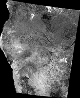
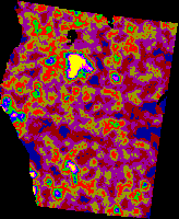
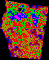
Fig 1 Fig 2 Fig 3
Let’s see what anomalies one can find in the LESSA data, and then
we’ll discuss how to combine different LESSA results and/or results
of the other studies. We’ll start with the "digital fields"
anomalies.
First of all we can find regions with absolutely unusual values.
In the NNW stripes density, Fig 2, there is a region to the north
of the image center with density, 135-175, that is much greater
then anywhere else in this territory.
Another anomaly example - region differs from the neighborhood
in general. Stripes density, Fig. 3, in the northern section of
the territory is lower if compare with the southern section. All
density values are in the range 480-777. All values above 700 are
only in the northern part and all values below 525 are only in the
southern part. Another anomaly of the same kind is an elliptical
region of the low NE stripes density, Fig. 4, near the image center
(though density of all stripes in this region is high enough).
Next anomaly is a shape anomaly and first of all - straight linear
borders or lines. They can’t be result of LESSA operations - all
calculation "windows" are circular. Long straight lines
must attract our attention, though we must check that there is no
artificial origin in such anomalies.
The most strongly marked anomaly of this kind - almost rectangular
region with low stripes density on the SW, Fig 3.
We can also find long straight gradient zones. For example, there
are two straight latitudinal gradient zones between the northern
and the southern parts in the stripes density field, Fig 3.
Straight lines we can find also in the extremum location. In the
SE stripes density, Fig. 4, we can see maximum regions arranged
in the straight SE line (in the center of the East image side).
This situation could be caused by wide fault zone.
Even more often we can find lines of minimum extremums. For example,
latitudinal zone in the center of NNW stripes density image, Fig.
2. It’s difficult to find this zone in maximums as there are maximums
of differently oriented stripes. But this zone we can also see in
the elongation "field".
There are anomalies in the so called "vector fields",
say in the elongation lines. We can see compact regions with unidirectional
lines, Fig. 5. Also there could be linear zones of the elongation
lines break. This anomaly can occur if along such "break zone"
there are stripes orthogonal to the main texture orientation. For
example, to the north from the image center we can see NW-lines
block, with vertical "break line" on its east side.
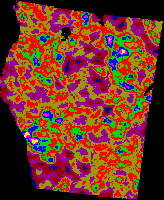
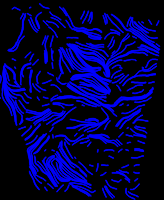
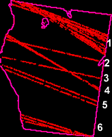
Fig 4 Fig 5 Fig 6
Now let’s discuss lineament anomalies. Main LESSA lineaments parameter
- is validity measure (how well lineament is filled with stripes).
Absolute validity value itself is not interesting. Also, is not
interesting if this value for one lineament is a bit higher than
for another lineament. But it’s important if validity of one or
a couple of lineaments is much higher then validity of the other
lineaments of the same direction. On the Fig. 6 there are all WNW
lineaments with validity above 55 - maximal validity, 181, has lineament
4, next validity, 141, has lineament 1.
The other LESSA lineaments property is there groping - zones or
bunches. There is an example of a bunch in Fig. 6, number 1. Parallel
lineament zones we can see on Fig 7, where most valid lineament
in each of 8 directions is displayed along with 9 most valid NE
lineaments. Those 9 lineaments form 3 equidistant parallel zones.
Next lineaments feature that we can take into account - lineaments
nodes. Such node can be an evidence of the anomalous rocks density.
There are two definite nodes on the Fig. 7 - in the center and on
the west side.
So we discussed main anomalies that we can fined in the LESSA data.
It’s very substantial to compare independent LESSA data and (what
is more important) LESSA data with results of the other geological
studies. First, let’s compare different independent LESSA data anomalies,
for example, LESSA lineaments and "digital fields", or
elongation lines and stripes density.
Linear extremum zone and lineament. There are 2 lineaments, Fig
6, number 5 on the northern and southern sides of the latitudinal
minimal zone of NNW stripes density, Fig. 2, in the center.
Elongation lines and lineaments. On the sides of the NW elongation
lines block that we discussed in the Fig. 5 there are most valid
WNW lineaments and meridianal lineaments that are also among the
most valid, Fig. 8. There is also minimum region in the NE stripes
density right there, Fig. 4.
Elongation lines and stripes density. The southern "rectangular"
region (stripes density minimum, Fig. 3) coincides with the region
of NE elongation lines, Fig. 5.
Linear gradient and lineament. Linear gradient zone at the southern
"rectangular" region (minimum of the stripes density,
Fig. 3) coincides with the pair of the most valid NW lineaments
(Fig. 9, yellow lines pair in the south-west of image). Another
example, more complicate. Between the northern part of the image
with higher stripes density and the southern part there is the most
valid latitudinal LESSA lineament (Fig. 9, yellow line). And there
are two straight linear zones along that lineament. But may be this
situation has no geological reasons. Lineament could be cased by
the land tenure difference as it goes along Namibia border with
the northern states, and the density difference could be result
of the climate difference.
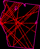
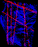
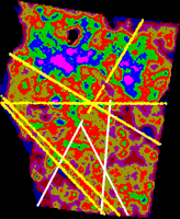
Fig 7 Fig 8 Fig 9
We discussed LESSA data anomalies. For several anomalies geological
interpretation was found. Let us stress that we must not expect
LESSA to detect all lineaments and geological structures of the
region. If some structures are not detected it does not mean that
they are not reliable, and it does not mean that LESSA is not reliable
- just in this image and with this calculation parameters this structures
are not "visible".
Let’s compare detected anomalies with the data presented in the
Dr.Branco Corner research, where lineaments derived from magnetic
data are mapped (Geophysical mapping
of major structures of southern Africa and an assessment of kimberlite
correlation). There are 10 lineaments on this territory and
8 of them are confirmed by LESSA lineaments, one by digital fields.
First of all, three NE lineament zones on Fig. 7, correspond to
well known geological structures - transform faults continental
continuation. Northern zone corresponds to Lukapa zone (a lot of
kimberlite locations), middle zone corresponds to Omaruru lineament
zone and the southern zone corresponds to Trans Southern African
Lineament Zone.
Two first NNW LESSA lineaments, Fig. 7, coincides with Khoisan
lineament (white line in the Fig. 9).
Lineaments junction in the center, Fig. 7, coincides with intrusion
marked by Dr. Corner above Khoisan and Kudu lineaments junction
(inclined white lines in Fig. 9).
Now let’s see how LESSA results can help to extrapolate lineaments
detected in the other data. The most valid WNW LESSA lineament (4th
in Fig. 6, let’s call it Santa Mariah according to the cap that
it crosses) is stressed in NNW stripes density (Fig. 4) by linear
gradient in its western part and by chain of minimums in the center.
This lineament appears to be a continuation of the lineament detected
in altimetry data (The
Angola Hollow Faults). This lineament crosses the cretaceous
alkaline intrusion Serra da Nevi and a set of small alkaline or
carbonatite intrusions, several clusters of kimberlite bodies, particularly,
to the southeast from Kassinga and in the lower part of the Quito
river.
There is a special situation with Kalahari lineament (vertical
white line, Fig. 9). It is not confirmed by LESSA lineaments well
enough, but it is confirmed by "digital fields". In the
image center it goes along the vertical border of the low stripes
density region (Fig. 9), and on the south it goes along the vertical
border of the high NE stripes density region (Fig. 4). May be it
could be extrapolated to the north, as there are many linear anomalies
- "break line" (Fig. 5), chain of maximums in submeridional
stripes density and one of the most valid short lineament.
Another extrapolation example. The most valid NNE short lineament
(yellow line, Fig 9) is an exact continuation of Kudu lineament
(white line, Fig. 9), though this southern part detected in magnetic
data is badly manifested in LESSA.
|